ECPINS
World-Leading WECDIS
Precision & Safety
ECPINS enables the navigator, watch officer, and bridge crew to navigate a warship with precision and safety using all the vessel’s sensors to plot its position on a powerful electronic chart display.
Military grade
ECPINS is the pre-eminent tool for the military navigator. The operator has access to advanced navigation, planning, and watchkeeping tools developed through many years of collaboration with military professionals and intensive use at sea on a variety of surface and subsurface naval vessels.
Standards
ECPINS is independently certified to meet the standards of IMO ECDIS Edition 4, NATO WECDIS Edition 2, IHO S-52 Presentation Library, and IMO INS (Integrated Navigation System) performance standard.
Interfaces
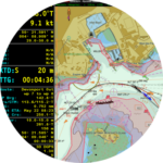
ECPINS presents the operator with navigational information, sensor input, and electronic charts on 3 main screen layouts, with a selection of alternatives for specialized purposes such as planning. A central feature of each layout is a chart window, which the operator can pan, scroll, or zoom as needed. Operator control is by 3-button trackball keyboard, which is enhanced by standard and user-defined shortcut keys.
Watchkeeping
 In ECPINS, the watchkeeper has good tools for monitoring position and progress on the electronic chart display. To confirm the own ship’s position, the operator can simultaneously display one or more of other position sources, such as an INS, EP, or alternative GNSS. Further confirmation is available by overlaying the radar image or by generating a position fix. The operate can lay down fixes (visual, running, or time-specific) with speed and accuracy. Lines of position include bearing (visual, EO/IR device, etc.), range (radar, EO/IR device, etc.), transit, HSA, VSA, and more.
Planning
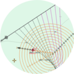
 ECPINS offers the navigator all the essential planning features required by ECDIS and WECDIS plus advanced tools for demanding military operations. The navigator can plot, save, and scan for hazards any number of routes. Configurable route characteristics include planned speeds, wheel-over points, cross-track warning and alarm distances, action points, set & drift predictions, height of tide predictions, waypoint naming, and turn curves.
Chart Display
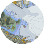 ECPINS’s chart display engine is powerful and versatile, capable of displaying a vast range of chart formats including all common electronic nautical chart types, NATO AMLs, encrypted charts, land contour maps, and satellite photos. Since this engine is entirely proprietary, developed by OSI engineers over decades, OSI can adjust and improve it in a timely and effective manner.
Situational Awareness
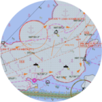
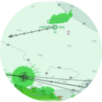 In the demanding military environment, ECPINS offers the operator enhanced situation awareness afforded by the display, management, and monitoring of contacts. In addition to a radar image overlay from either radar, the operator can control the display of contacts as AIS (from a connected receiver), ARPA (received from 1 or 2 connected radars), combat system (near real-time updating) or similar source. ECPINS applies MIL-STD-2525C symbology to these contacts, displays their movement, logs their tracks, and offers the operator detailed information upon interrogation.
ECPINS Future
Upon the release of ECPINS Generation 7, a navy, fleet, or vessel can have a system that complies with WECDIS 3 requirements by deploying ECPINS 7 plus six software modules; adding the Sub Ops module completes the requirements for sub-surface use.
Additional modules contain features that extend ECPINS’s capabilities in specific areas, such as aircraft operations and digital radar control. Typically, these are relevant to a particular platform, such as a CV or an MCMV, or to a specific capability such as autopilot or small craft tracking.
ECPINS Software Modules
OSI offers a variety of optional Software Capability Modules and features. A customer can purchase any selection of these for a specific vessel, vessel class, or flotilla, or for use fleet-wide.
View Software Modules