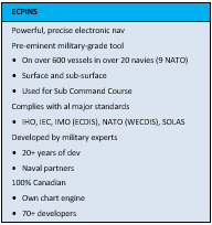
For all its warship navigation systems, OSI uses the ECPINS (Electronic Chart Precise Integrated Navigation System). This application enables the navigator, watch officer, and bridge crew to navigate a warship with precision and safety using all the vessel’s sensors to plot its position on a powerful electronic chart display supported by enhanced situation awareness in the form of overlaid radar imagery, contacts, and operational areas.
ECPINS is the pre-eminent tool for the military navigator. It is in service on at least 700 vessels worldwide in over 25 navies. ECPINS meets all the requirements of NATO’s WECDIS Edition 2 specification and at least 70% of Edition 3 (2017). The operator has access to advanced navigation, planning, and watchkeeping tools developed through many years of collaboration with military professionals and intensive use at sea on a variety of surface and subsurface naval vessels.
While ECPINS’s capability is well beyond that of a commercial-grade ECDIS, it maintains a foundation in safety. ECPINS complies with all major electronic chart system standards, including those of the IHO, IEC, and IMO. IMO ECDIS compliance is certified by an independent testing agency.
Interfaces
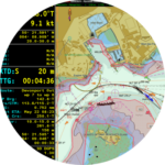
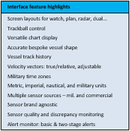
ECPINS presents the operator with navigational information, sensor input, and electronic charts on 3 main screen layouts, with a selection of alternatives for specialized purposes such as planning. A central feature of each layout is a chart window, which the operator can pan, scroll, or zoom as needed. Operator control is by 3-button trackball keyboard, which is enhanced by standard and user-defined shortcut keys.
Contents
- Interfaces
- Watchkeeping
- Planning
- Chart display
- Situational awareness
- System features

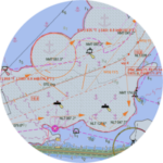
At larger viewing scales, the own ship’s position is marked by an outline of the own ship, its dimensions, sensor locations, and superstructure precisely tailored to the particular vessel, facilitating precise manoeuvres and measurements. ECPINS displays the own ship’s heading, current movement, and past track in detail. The operator can customize the time zone and system units for display – such as Lat/Lon vs GEOREF vs MGRS, meters vs feet, NM vs Km, — while entering data in any of these. For navigation in latitudes greater than 70°, the operator can change to Polar Grid coordinates and a Polar Projection.
ECPINS connects to all relevant military and commercial navigation sensors enabling the operator to set a preferred source for each of position, heading, speed, wind, attitude, helm, depth, and others. With the source selected, the operator can view and use the data, as well as have ECPINS monitor the sources for quality and discrepancies.
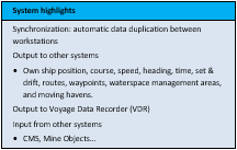
Alerts concerning sensor data, and for navigation settings and situational awareness, appear in a dedicated Alert Monitor for easier management. Behind the scenes, all data (such as routes, charts, and updates) and selected system settings (such as position source and colour scheme) can be synchronized between ECPINS computers across a pair of workstations or a large-scale bridge system.
Watchkeeping

In ECPINS, the watchkeeper has good tools for monitoring position and progress on the electronic chart display. To confirm the own ship’s position, the operator can simultaneously display one or more of other position sources, such as an INS, EP, or alternative GNSS. Further confirmation is available by overlaying the radar image or by generating a position fix. The operate can lay down fixes (visual, running, or time-specific) with speed and accuracy. Lines of position include bearing (visual, EO/IR device, etc.), range (radar, EO/IR device, etc.), transit, HSA, VSA, and more.
Where a position fix derived from an electronic source is not available, unreliable, or being denied, the operator can generate a continuous position using DR, either auto or manual. In automatic mode ECPINS uses the speed and heading inputs; in manual the operator enters these values. The operator has the option to have the estimated position affected by set and drift, which can be calculated fix to fix or by sensor or operator input.
The own ship’s progress along the designated route is readily visible to the watchkeeper using route monitoring tools that show XTD, waypoints, legs, relevant DTG, TTG, and ETAs. Alerts warn when the cross-track distance exceeds the leg’s limits. Enroute position monitoring is made easy with an array of electronic bearing lines (EBLs), hazard bearings, and parallel indices.
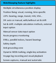
To alert the operator to shallow hazards and other dangers, the operator can activate an ant-grounding cone, which scans the charted areas ahead. This scan depends on the safety depth setting, which also highlights unsafe water and object across the chart display. In the event of a man overboard, with a single keystroke the operator can mark the position, monitor its bearing and range, and view the person’s potential position.
Voyage log recording ensures that all sensor input, system events, and settings are routinely stored for up to 120 days. These logs are available for visual playback and systematic on any ECPINS computer
Planning
ECPINS offers the navigator all the essential planning features required by ECDIS and WECDIS plus advanced tools for demanding military operations. The navigator can plot, save, and scan for hazards any number of routes. Configurable route characteristics include planned speeds, wheel-over points, cross-track warning and alarm distances, action points, set & drift predictions, height of tide predictions, waypoint naming, and turn curves.
The navigator can plot a turn curve using a simple radius or advance and transfer data, which can be pulled from performance tables saved with the vessel. Once a turn curve is plotted, the planner can skew it to suit the circumstances of current and wind, or have ECPINS automatically adjust the curve according to the tidal stream predicted at the time of arrival at the turn. This is possible when ECPINS is connected to an (optional) tide and current prediction database such as Admiralty TotalTide.
For a search-and-rescue emergency, the operator can have ECPINS automatically lay out a SAR route according to one of several standard patterns, adjusted for wind, current, and starting location.
Once a route is plotted, the navigator can calculate, review, and set a PIM (Position of Intended Movement), which ECPINS displays both along the route and in a Route Monitor. Speculative PIM calculations are possible enroute.
ECPINS provides for the many elements that support a planned voyage in British Admiralty navigation practice (as described in BR45), including clearing lines/bearings, markers, limiting danger lines, fixing points, user-defined objects, lines and areas. Among these areas are NATO-standard waterspace management areas, moving havens, and 4W grids. The navigator can prepare these in advance for display only when needed. All the elements required for a particular voyage can be packaged into a voyage plan, for instant display as well as duplication to other systems.
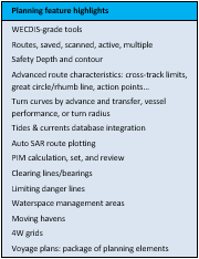
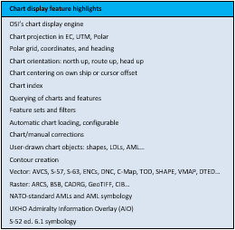
Chart Display
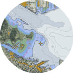 ECPINS’s chart display engine is powerful and versatile, capable of displaying a vast range of chart formats including all common electronic nautical chart types, NATO AMLs, encrypted charts, land contour maps, and satellite photos. Since this engine is entirely proprietary, developed by OSI engineers over decades, OSI can adjust and improve it in a timely and effective manner.
Thanks to the display engine, the ECPINS operator can install an extremely wide range of chart formats. Formats ECPINS can use include: vector nautical chart in S-57, S-63, ENCs, high-res, DNC, C-Map, TOD0; raster nautical chart formats such as ARCS and BSB; NATO-standard AMLs Editions 3, 2, or 1, including IWC, CLB, MFF, ESB, LBO, SBO, RAL, and AMC; land, air, GIS map formats including: VMAP, DTED, NITF, CADRG, Shape, and GeoTIFF.
To supplement and temporarily update these charts, ECPINS enables the operator to create manual corrections (MIOs), through which any charted object, line, or area defined in a catalogue (WECDIS, AML, DNC, S-57, etc.) can be drawn and stored in a set for optional display. Where needed, complex geometries such as a corridor/lane, ellipse, sector, or arc are possible in these user-defined layers.
On the chart display, the operator has immediate access to information on any selected chart object and on the chart itself, such as number, update date, security classification, and composition scale. Where a chart has embedded information such as notes, files, or images, these too are revealed by query. On vector charts, where features are organized into dozens of layers, the operator can control the display of individual layers or pre-defined sets for particular purposes such as pilotage or coastal/ocean transit. Sophisticated feature filters facilitate the display of object from one chart type beside that of another chart. The result is a seamless, “multi-fuel” chart display.
Situational Awareness
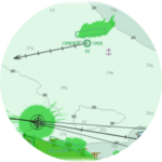
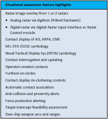
In the demanding military environment, ECPINS offers the operator enhanced situation awareness afforded by the display, management, and monitoring of contacts. In addition to a radar image overlay from either radar, the operator can control the display of contacts as AIS (from a connected receiver), ARPA (received from 1 or 2 connected radars), combat system (near real-time updating) or similar source. ECPINS applies MIL-STD-2525C symbology to these contacts, displays their movement, logs their tracks, and offers the operator detailed information upon interrogation
To supplement these sensed contacts, the operator can create a contact on the fly, giving it attributes such as type, affiliation, speed, and heading. Where the heading is no longer known, ECPINS displays a furthest-on circle that expands from the last known position.
In high-traffic zones, where many such contacts can overlap, ECPINS enables the operator to control the display of contacts by criteria such as range, class, speed, CPA, and TCPA. For further de-cluttering, the operator can have ECPINS automatically associate obviously similar contacts, that is, convert 2 or 3 contacts into one. Range-based alerts can be set for contacts lost.
ECPINS can help the operator identify potential conflicts with contacts by alerts triggered by criteria such as range, CPA, and TCPA. For security purposes, the operator can set up a guard zone around the own ship, or an exclusion zone in a particular area, which ECPINS monitors for any contact. For more sophisticated threat identification, a graduated force
protection scheme can be implemented whereby ECPINS alerts the bridge crew to a contact that match a range, speed, and heading criteria.
Where interception is required, ECPINS can assess its feasibility given vessel performance and then recommend a route. To assist with positioning against a target or for defensive postures, the operator can display pre-defined vessel templates that move with the ship; typical templates portray a firing arc, a weapon’s range, a radar sweep zone, or a blind spot.
System Features
 These back-end features make a variety of system configurations possible.