S-100 introduces a new concept called “interoperability” between the chart layers displayed in the ECDIS. Previously, each chart would “stack” on top of the chart underneath. All information on the charts underneath would be covered by the chart above. Querying information would be challenging and required extra effort to move down through the chart layers. With S-100 and interoperability enabled, S-102 bathymetric data can be interleaved above S-101 depth areas and below other S-101 text, point, or line features. The result is a much more seamless presentation of information, taking advantage of the power of S-100.
OSI’s S-100 Technology
Pioneering the Next Generation of Maritime Safety and Efficiency
OSI’s ECPINS® WECDIS now supports the International Hydrographic Organization (IHO)’s next generation S-100 electronic chart data.
ECPINS powerful chart engine and innovative user interface allows the navigator to easily configure, display, and combine S-100 datasets, supporting a safer and more efficient approach to navigation and, when combined with ECPINS’ powerful tactical features, ensures operational advantage.
ECPINS’ advanced user interface will permit S-100 time dependent objects, such as height of tide, surface currents, and weather conditions, to display at a user defined date & time (to support the navigator when planning) or in real time (when the navigator is executing their plan). Incorporating the full scope of S-100 Phase 1 and 2 products, advanced interoperability settings, and support to mission planning and execution, a navigator with ECPINS and S-100 benefits from enhanced safety of navigation, tactical advantage, and information superiority.
ECPINS’ chart display engine is powerful and versatile, capable of displaying a vast range of chart formats including all common electronic nautical chart types, NATO AMLs, encrypted charts, land contour maps, and satellite photos. Since this engine is entirely proprietary, developed by OSI engineers over decades, OSI can adjust and improve it in a timely and effective manner. As the chart engine is developed by OSI, not a 3rd party, OSI ensures a closed environment protected against external threats.
ECPINS 7 integrates all of the IHO’s Phase 1 products:
• S-101 ENC
• S-102 Bathymetric Surface
• S-104 Water Level Information
• S-111 Surface Currents
• S-124 Navigational Warnings
• S-129 Under Keel Clearance Management
ECPINS 7 also integrates the following IHO Phase 2 products:
- S-122 Marine Protected Areas
- S-123 Marine Radio Services
- S-127 Marine Traffic Management
- S-131 Marine Harbour Infrastructure
- S-411 (WMO) Ice Information
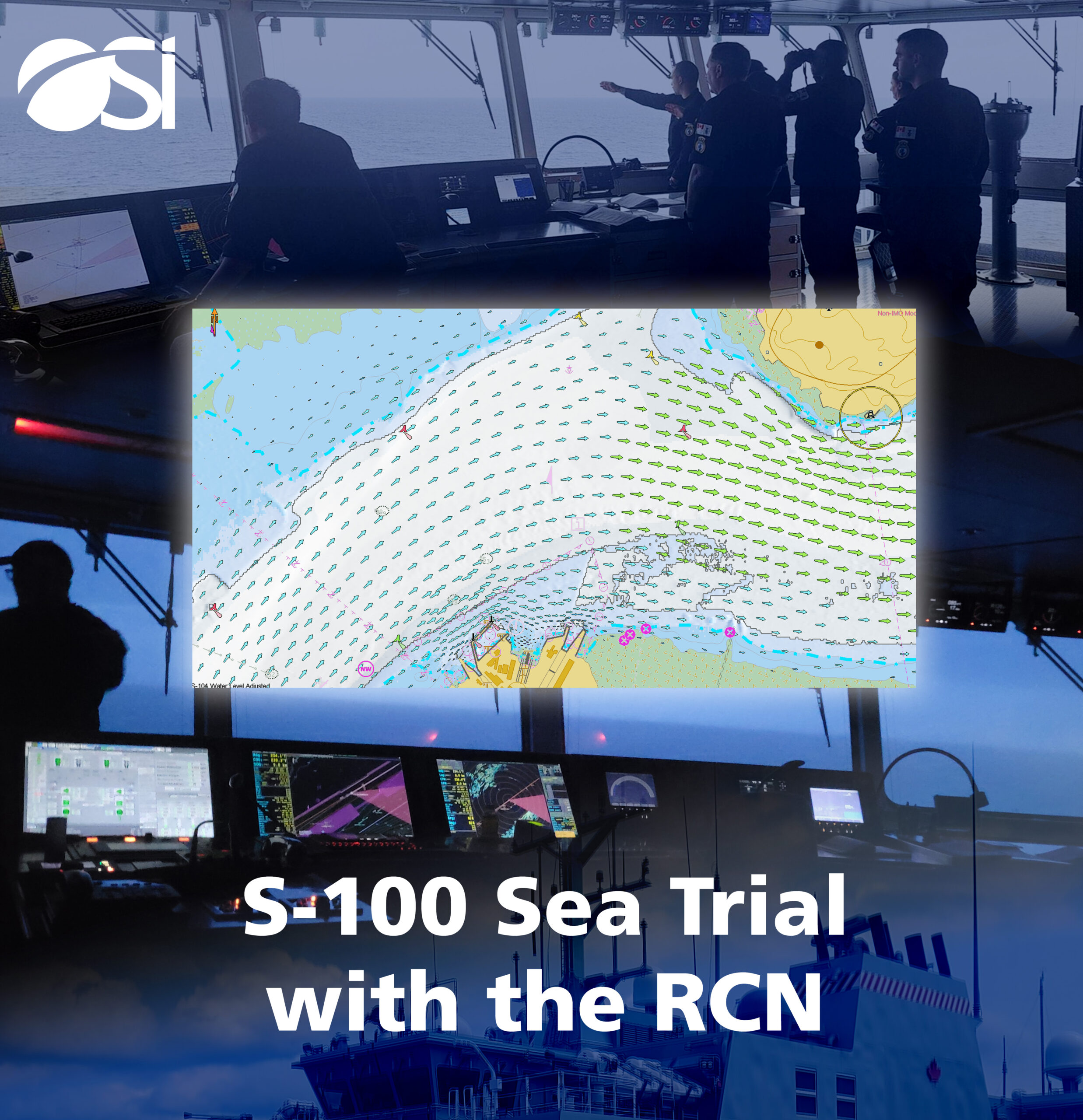
The power of S-100 data allows S-101 ENC data to be supplemented with high-resolution S-102 gridded bathymetric data, and adjusted in real-time with S-104 water level information. This allows the navigator to make use of all available safe water based on their planned time of arrival at each waypoint.
The animation contains five different S-100 products produced by Canadian Hydrographic Service (CHS) and the Canadian Coast Guard (CCG):
- S-101 ENC
- S-102 Bathymetric Surface
- S-104 Water Level Information for Surface Navigation
- S-111 Surface Currents
- S-124 Navigational Warnings
The base S-101 ENC is enhanced with the S-102 detailed bathymetric data. Height of Tide corrections are applied by the S-104 data which causes the safety contour to expand and contract over time. S-111 surface currents are visible as the tidal stream arrows. The arrows change size and colour based on the current speed and the legend is visible on the bottom of the display. Finally, an S-124 navigation warning appears in the bottom left of the display part way through the animation.
What does this mean for the Navigator?
S-102 bathymetric surface will provide depth information in much greater fidelity than traditional soundings, supporting precise navigation in confined waters and enhanced application of bathymetric navigation techniques. In combination with S-104 (Water Level Information) the navigator is no longer reliant on static, manually generated go / no-go areas in pilotage waters, but can instead see the limits of safe water moving dynamically on the ECPINS display in real time. In peacetime this enables access to the full extent of navigable waters significantly enhancing safety; in the tactical environment this feature provides superior freedom of manoeuvre and tactical advantage. The seamless integration of other Phase 1 products in ECPINS, such as S-111 (Surface Currents) and S-124 (Navigation Warnings), further enhances the ability of the navigator to combine, display, and exploit the critical information which is fundamental to the conduct of safe navigation.